


First author article in Artificial Intelligence in Geosciences
First author article by Jan Matwiejczuk et al.
Enhancing coarse bathymetric grids using a generative model: An arctic case study
Jan Matwiejczuk, Matthew Danielson, Jens Jasche, Larry A. Mayer, Rezwan Mohammad, Thi Tam Truong, and Martin Jakobsson, 2026. Enhancing coarse bathymetric grids using a generative model: An arctic case study. Artificial Intelligence in Geosciences: 7, 100284. https://doi.org/10.1016/j.aiig.2026.100284

Abstract
Bathymetric mapping of ice-covered polar seas remains a major challenge. Persistent sea ice restricts systematic surveys, while icebreaking operations degrade multibeam echosounder (MBES) data quality through noise, hull vibrations, and ice interference. As a result, digital terrain models (DTMs) from bathymetric surveys in ice-covered regions are often fragmented, coarse, and incomplete, limiting interpretation of seafloor morphology, including glacial landforms used to infer former glacier extent and ice-sheet dynamics. Conventional interpolation for upscaling and gap filling often oversmooths morphology and suppresses geomorphologically important landforms. We developed a generative super-resolution approach to reconstruct bathymetry at 25 m resolution from degraded 100 m and 200 m inputs (4× and 8× super-resolution). We additionally examine whether fine-scale glacial bathymetric structure can be inferred from coarser geomorphological context. To address the issue of limited bathymetric training data from polar regions, we trained a conditional diffusion model on high-quality terrestrial DTMs containing landforms analogous to glaciated submarine settings. The model was evaluated on held-out Arctic MBES bathymetry from offshore northern Greenland using patch-based tests, full-grid evaluation, and qualitative assessment. Compared to bicubic interpolation, the model improves elevation-distribution agreement, feature-space similarity, and spectral consistency. However, gains in spatial cross-correlation remain limited, suggesting that coarse geomorphological context alone may provide insufficient information for reliable inference of fine-scale landforms. Qualitative assessment suggests clearer expression of glacial landforms, including lineations and retreat moraines, where only weak traces were visible in coarse bathymetry. These results suggest that proxy-trained generative super-resolution can serve as an interpretation-enhancing post-processing tool for degraded Arctic bathymetric grids.
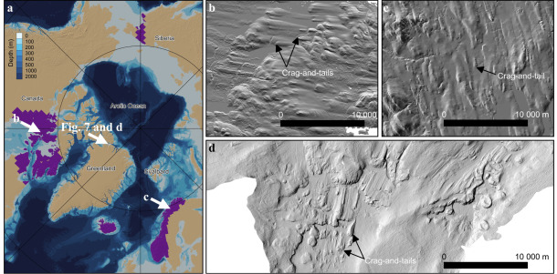
Fig. 1. Overview of the proxy training and target domains. (a) Spatial extent of the used terrestrial training dataset, shown in purple. (b,c) Hillshade examples from the Canadian and Norwegian terrestrial DTMs, highlighting glacial landforms analogous to those in glaciated submarine settings, including crag-and-tail features. (d) Example from the target Arctic MBES domain showing comparable submarine glacial landforms.
Last updated: 2026-11-03
Source: ines.jakobsson@geo.su.se