


To predict Antarctica’s future, scientists need to see beneath the ice
Professor Arjen P. Stroeven from Stockholm University and the Bolin Centre for Climate Research is one of 80 scientists behind a new international review highlighting major gaps in our knowledge of Antarctica’s coastal zone. The researchers warn that what we do not yet know about the landscape beneath and around the Antarctic ice could be limiting our ability to predict future sea-level rise.
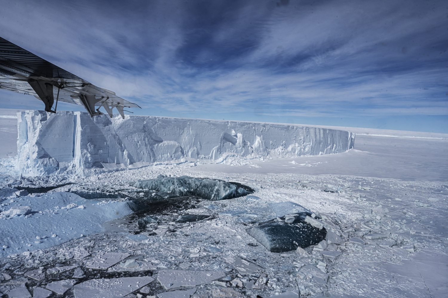
The edge of Riiser-Larsenisen, the largest ice shelf of Dronning Maud Land, Antarctica. If the ice shelf edge retreats through the production of many large tabular icebergs, upstream ice may accelerate, leading to more ice entering the ocean to melt and cause rising sea levels. The study of the stability of Riiser-Larsenisen by researchers in iQ2300 is supported by the Swedish Polar Research Secretariat as part of their Polar Research Process. Photograph by Kadir van Lohuizen
From space, Antarctica can look like one of the best-observed places on Earth. Satellites continuously track the movement and changing surface of its vast ice sheet. But beneath the ice, much of the landscape remains hidden.
Published in Reviews of Geophysics, the review brings together current knowledge of the Antarctic coastal zone, where ice, ocean, atmosphere and the underlying bedrock interact. The authors identify major gaps in observations and argue that filling them could be crucial for improving projections of how Antarctica will contribute to global sea-level rise.
The paper was coordinated through the Scientific Committee on Antarctic Research (SCAR) RINGS Action Group and brings together researchers from 17 countries, spanning glaciology, oceanography, geophysics and atmospheric science.
A hidden landscape beneath the ice
The Antarctic coastal zone is where some of the processes controlling ice loss take place. It is also one of the least well-observed parts of the continent.
Where the ice sheet meets the ocean, several systems interact. Ocean water can melt ice from below, while the shape of the bed beneath the ice can influence how quickly glaciers flow towards the sea. The grounding zone – where ice resting on the bed begins to float – is particularly important.
These processes are closely connected. Changes in the ocean can affect an ice shelf, which in turn can influence how effectively it holds back the ice behind it. Changes in ice flow can then affect how much ice is discharged into the ocean. The shape and properties of the bed beneath the ice can further influence how the ice responds.
The problem is that much of this landscape remains poorly mapped.
Satellites provide remarkably detailed information about the surface of the ice, including its elevation and movement. But they cannot directly see through kilometres of ice to map the bedrock below. This means that one of the fundamental pieces of information needed by ice-sheet models is still missing in many parts of Antarctica.
Satellite data alone cannot reliably estimate ice loss into the ocean, and computer models alone cannot predict future change. Both depend on accurate knowledge of bed topography. Observations like those proposed in this paper provide a key missing piece,” says lead author Kenichi Matsuoka of the Norwegian Polar Institute.
Mapping Antarctica’s blind spots
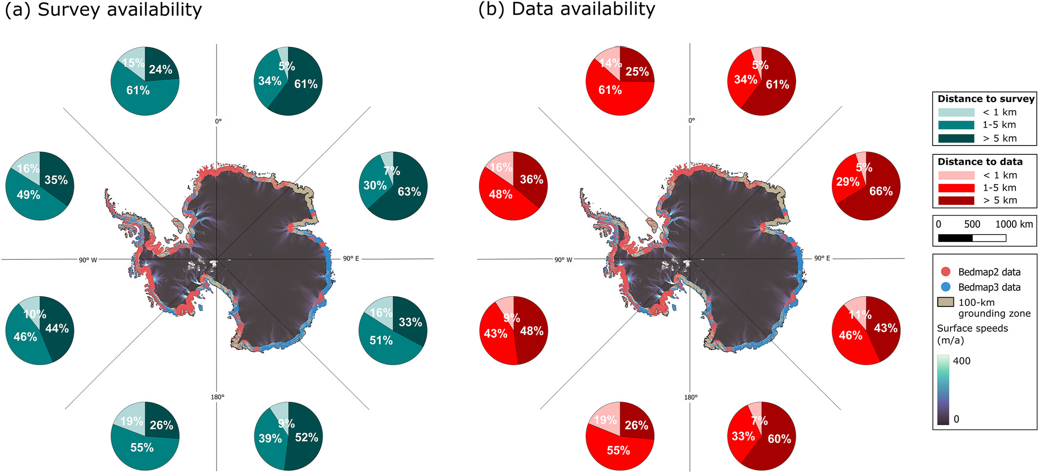
Observations of the Antarctic ice sheet’s hidden landscape are unevenly distributed, with particularly large gaps along the coastal zone. The maps show the availability of ice-penetrating radar surveys (a) and bed-elevation data (b), highlighting where more observations are needed to improve our understanding of ice flow and future sea-level rise. Adapted from Matsuoka et al. (2026), Reviews of Geophysics.
The review highlights persistent gaps in direct observations of the bed beneath the Antarctic ice, as well as the cavities beneath ice shelves and the seabed beyond them.
This matters because the landscape hidden beneath the ice helps determine how ice flows towards the ocean. It can also influence how warm ocean water reaches the underside of ice shelves, potentially affecting how quickly they melt from below.
Ice-sheet models are sensitive to these conditions. If the underlying landscape is poorly known, even sophisticated models can produce very different projections of how the ice sheet might respond in the future.
This is also where ongoing research such as iQ2300, an international project coordinated by Stockholm University, can contribute. The project investigates how the East Antarctic Ice Sheet could contribute to sea-level rise by 2300, combining field observations, remote sensing and modelling. Its researchers are collecting new data in East Antarctica to improve knowledge of ice thickness, the landscape beneath the ice and conditions near the grounding line – precisely the kinds of observations identified as important by the RINGS review.
Stroeven’s involvement in the RINGS review is connected to iQ2300, which has received RINGS endorsement. Two other iQ2300 researchers – Katrin Lindbäck and Ruth Mottram, alongside Stroeven – are also co-authors of the review.
iQ2300 is a microcosm of the broader Antarctic research community. We are a highly coordinated group from diverse nations and backgrounds, united by our drive to gather crucial, hard-to-obtain field data. Using these data, we model changes in the East Antarctic Ice Sheet within the global environmental system to provide more robust estimates of sea-level rise and develop solutions for Swedish coastal communities. We accomplish all of this with the full backing of the Swedish Polar Research Secretariat, a government agency that provides logistical support both on the ice and from polar vessels,” says Stroeven.
A coordinated effort to fill the gaps
No single country can map the entire Antarctic coastal zone. The authors therefore call for greater international coordination of observations, rather than individual research teams surveying the same areas while other regions remain poorly covered.
The review proposes a framework for coordinating future surveys through the RINGS Action Group under SCAR, with support from the Council of Managers of National Antarctic Programs (COMNAP).
The proposed observations would target different parts of the Antarctic coastal system, from the grounding zone and the ice sheet inland of it to ice shelves and the seabed offshore. Together, these measurements could provide a more complete picture of the processes controlling Antarctic ice loss and improve the observations available to ice-sheet models.
Uncoordinated surveys risk leaving gaps or duplicating effort. This paper provides an evidence-based framework to support coordinating RINGS activities under SCAR and COMNAP, helping to build more comprehensive datasets for improved sea-level projections,” says Matsuoka.
The authors see internationally coordinated observations as a possible stepping stone towards the next International Polar Year in 2032–33.
For Antarctica, understanding the future may depend partly on understanding the landscape hidden beneath its ice. Better observations of this unseen terrain could help scientists narrow one of the major uncertainties in projections of future sea-level rise.
Learn more about the review
The review, Toward an Improved Understanding of the Antarctic Coastal Zone and Its Contribution to Future Global Sea Level, was published in Reviews of Geophysics in September 2026.
The work was coordinated through the SCAR RINGS Action Group and involved researchers from 17 countries.
Last updated: 2026-10-02
Source: Department of Geological Sciences